Nanga Parbat Expedition
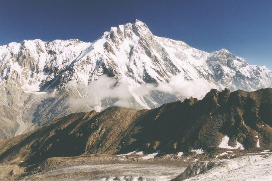
nanga-parbat Nanga Parbat, also known as Diamir or Naked Mountain, is the ninth-highest mountain in the world, soaring to an elevation of 8,126 meters (26,660 feet) above sea level. Nestled in the western Himalayas of Pakistan's Gilgit-Baltistan region, Nanga Parbat is renowned for its challenging terrain and unpredictable weather conditions, earning it the nickname "Killer Mountain."
Location:
Nanga Parbat lies in the Diamer District of Gilgit-Baltistan, Pakistan, approximately 130 kilometers northeast of Gilgit, the regional capital. The mountain stands as the centerpiece of the Nanga Parbat massif, a vast mountain range encompassing over 100 peaks.
Weather:
Nanga Parbat's weather is characterized by extremes varying significantly with altitude and season. The lower valleys experience a warm, temperate climate, with summers ranging from 20 to 30 degrees Celsius (68 to 86 degrees Fahrenheit) and winters with temperatures between 0 and 5 degrees Celsius (32 and 41 degrees Fahrenheit). As the altitude increases, the weather becomes progressively colder and harsher, with the summit region experiencing arctic conditions year-round.
Basecamps:
Nanga Parbat's basecamps serve as essential staging grounds for mountaineers embarking on expeditions to the summit. Each basecamp offers unique weather conditions:
- Taraning Basecamp (3,345 meters):Located at the confluence of the Rupal and Nanga Parbat valleys, Taraning Basecamp experiences mild summers with temperatures around 20 degrees Celsius (68 degrees Fahrenheit) and cold winters with temperatures dropping below freezing.
- Fairytale Meadow (4,200 meters): Named for its lush greenery and wildflowers, it offers a brief respite from the harsh mountain environment. Summers are pleasant, with temperatures around 15 degrees Celsius (59 degrees Fahrenheit). In comparison, winters are cold, reaching -10 degrees Celsius (14 degrees Fahrenheit).
- Mansehra Basecamp (5,300 meters): Situated at the foot of the Mazeno Glacier, Mansehra Basecamp experiences colder temperatures than lower basecamps. Summers are fantastic, with temperatures around 10 degrees Celsius (50 degrees Fahrenheit), and winters are harsh, with temperatures dropping to -20 degrees Celsius (-4 degrees Fahrenheit).
Routes:
Nanga Parbat offers three prominent climbing faces, each with its unique challenges and rewards:
- Diamir Face (West Face): The most straightforward and safest route, known for its less technical terrain and shorter overall ascent.
- Kinshofer Route: The original and most popular route on the Diamir Face.
- Mazeno Ridge: A long and challenging ridge with exposed terrain.
- Rupal Face (South Face): The longest and most challenging route, known for its steep slopes, treacherous ice walls, and unpredictable weather.
- Messner Route: Ascends the South South East Spur, a technically demanding route with exposed ridges and icefall hazards.
- Schell Route: Ascends the Upper South West Ridge, a challenging route with a mix of rock and ice climbing sections.
- Rakhiot Face (North Face): The least frequented and most technically challenging route, known for its incredibly steep slopes, unpredictable weather conditions, and avalanche risk.
- Buhl Route: Ascends the Rakhiot Face directly to the summit, a technically demanding and dangerous route.
- Japanese Route: Ascends the Rakhiot Face via a different line than Buhl's route.
Viewpoints:
Nanga Parbat offers several breathtaking viewpoints and stunning panoramas of the surrounding mountains and valleys. Some of the most famous views include:
- Taraning Basecamp: Fairy Meadows, also known as Pari Mahal, is a picturesque alpine meadow located at the base of Nanga Parbat, renowned for its enchanting beauty and serene atmosphere. This basecamp offers a close-up view of Nanga Parbat's Rupal Face, a massive rock wall considered one of the most challenging climbs in the world.
- Fairytale Meadow: From Fairytale Meadow, you can admire the majestic peak of Nanga Parbat rising above the lush greenery and wildflowers.
- Lattak Lake: This serene lake reflects the towering Nanga Parbat, creating a picturesque scene.
- Satpara Lake: This glacial lake offers a panoramic view of the Nanga Parbat massif, including Nanga Parbat, Rakaposhi, and Haramosh.
Mountaineering History:
Early Attempts and the First Summit:
- 1895: German mountaineer Albert F. Mummery leads the first attempt to ascend Nanga Parbat but perishes in an avalanche.
- 1953: Austrian mountaineer Hermann Buhl achieves the first successful summit of Nanga Parbat via the Rakhiot Face, setting a new standard in mountaineering.
- 1970: German mountaineers Reinhold Messner and Karl Maria Herrligkoffer summit Nanga Parbat via the Schell Route on the north face.
- 1971: Slovak mountaineers Ivan Fiala and Michal Orolin repeat Buhl's 1953 route, marking the first Slovak ascent.
- 1978: Austrian mountaineer Toni Kinshofer summits Nanga Parbat via the Kinshofer Route on the southeast face.
- 1982: Japanese mountaineer Tsuneo Hasegawa summits Nanga Parbat via the Mazeno Ridge on the south side.
Winter Ascent:
- 2016: A team of mountaineers, including Pakistani Ali Sadpara, Spanish mountaineer Alex Txikon, and Italian mountaineer Simone Moro, achieve the first winter ascent of Nanga Parbat.
Summery:
From Islamabad we drive to Chilas for 10 to 12 hours. The next day we will take a short ride to Bunar Farms where we will meet our porters and distribute our food and equipment for transfer to the Diamir Base Camp. After final preparation in Bunar Farms, we set off by jeep (3-4 hours) to Halaley Bridge from there one can reach to the base camp in two or maximum three days of walk. We enter an incredible wilderness of ice, rock and sky. Our entire stay is in absolute wilderness, we will take a colorful part of the Himalayan culture with us. Our scores of lively Kohistani, who are tough enough to sing and dance after the hard days work. The return trip is via the same route back to Islamabad.
Tour Detail:
Day 01 & 02: Arrival Rawalpindi/Islamabad
-
- Met upon arrival and transfer to hotel in Rawalpindi.
- Short rest, then drive to Islamabad, Ministry of Tourism.
- Complete necessary formalities and obtain climbing permit.
Day 03: Rawalpindi/Chilas
-
- Drive by road to Chilas.
- Transfer to Chilas Inn for overnight stay.
Day 04 – 06: Chilas to Diamir Base Camp
-
- Early morning drive from Chilas to Bunar Farms.
- Meet and hire porters at Bunar Farms.
- Same day drive to Halalay Bridge (3-4 hours drive, ascent 600m).
Day 07 – Day 36: Climbing
-
- 30 days of non-guided climb.
- Staff at base camp to assist during climbing period.
Day 37 – 38: Trekking Back to Hilalay Bridge and Drive to Chilas
-
- Early breakfast, leave base camp for trek to Hilalay Bridge.
- From Hilalay Bridge, drive by Jeeps to Bunar Farms.
- Meet van for return trip to Chilas and Islamabad.
Day 40: Rawalpindi
-
- Upon arrival, transfer to hotel in Rawalpindi.
- Evening sightseeing.
- If unable to fly on day 62, transfer from Gilgit to Islamabad by road.
Day 41: Rawalpindi
-
- De-briefing at Ministry of Tourism Islamabad.
- Evening free.
Day 42: Fly Back Home
-
- Transfer to airport for onward flight abroad.


