


Khane Valley Trekking Expedition
Information and pictures curtesy with thanks to our Bulgarian exploration team
The Khane Valley. Historical data
For many years, the Khane Valley has remained in the shadow of the neighboring Nangmah and Charakusa Valleys, immediately to the north and parallel to it. The main reason is Charakusa and Nangmah’s greater potential for first ascents on the walls of unclimbed peaks. That is why, in the 1990s and 2000s, this was a region of great interest for climbers due to its high quality granite. Currently, the main summits and walls in these two valleys have all been climbed.
To date, the Khane Valley has only been of any importance for the inhabitants of the village with the same name, providing pasture for their livestock. That is why most summits in the region were unnamed. The only ones having local names were the ones visible from the villages along the Hushe River, the Nangmah Valley and the pastures along the Khane River up to around 4300 m above sea level.
According to locals from Khane Village, the first foreigner to visit the valley, in 2001, was Korean; he came two more times and made two unsuccessful attempts to climb, most probably, the west wall of Agil Summit. The Koreans set camp at 4450 m and during their second visit opened a climbing route on a 250-meter high rocky outcrop nearby – probably reaching the very top of this satellite arête. Actually, this is the first route to be made here, yet too insignificant with all those big walls at the background, closing the valley in all direction. There are no data available about attempts on other summits or any exploration of climbing and mountaineering conditions.
According to the locals, another visit was made by an American, who came for a trekking after an expedition to Ogre Peak. She reached the foot of Great Tower using the approach by the big grassy terrace (First Terrace) along the side valley between Rila and Tangra Peaks to the east and Sofia Peak to the west.
Other ascents before 2011 were made starting from the Nangmah Valley on Black Tower (Sarigo) and Singu Chatpa (also called Singu Charpa and Great Tower). There is a small but very beautiful pointed peak towering over Khane Village, called Nauari Brakk (~3250 m); this was first climbed in 2009 by the local villagers Ali Mehmed and his son, Ruhal Ali. All other summits from both main ridges enclosing the valley are currently unclimbed
The Khane Valley. Geographic description
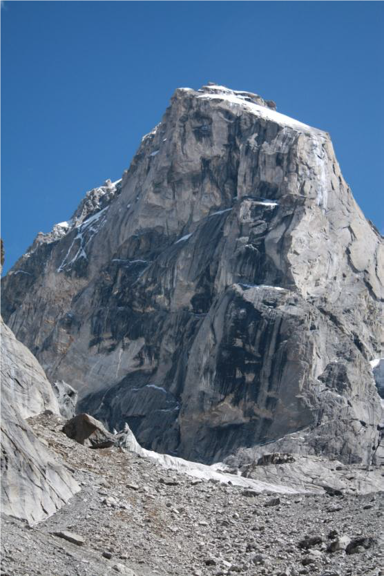
The Khane Valley is perpendicular to the Hushe River in Karakoram’s Masherbrum Range. To the north, it is separated from the Nangmah Valley by a serrated rocky ridge. Another rocky barrier delimits its southern edge, separating it from the small valley above Haldi Village (also Halde). To the east, where the main ridge makes an almost right-angle curve, is the upper part of the Tagas Valley. The ridge in the northeastern part of the valley borders on the upper side of the Lachit Valley and Glacier. The highest part of the Khane Valley is orientated in the north-south direction and the main part in the east-west-northwest direction. The right-hand (north) and left-hand (south) sides of the Khane Glacier and River are delimited by two main ridges. To the north, the right-hand one slopes down to the Nangmah Valley. Its main peaks are Black Tower (Sarigo) and Great Tower (Singu Chatpa).
The Khane Glacier flows south through the Khane Col (~5250 m). At first, it moves in the north-south direction, then, after an icefall at 4900 m, it abruptly turns west. At 4400 m, the glacier’s snout gives rise of the Khane River, flowing northwest. This is the place we named Second Terrace, where the Korean camp was situated. After a steep drop, the river forms a waterfall and flows through a wide grassy plain (First Terrace) used for pastures.
The main peaks situated on the left-hand side of the glacier above Khane Col are Hasho II (~6000 m), Peak 58 (~5930), Hidden Tower (or Peak 59, ~5830), Khanlim (Peak 60) and the Twins. On the right-hand side of the glacier are Peak 23 and Agil (~5680). At the base of the Twins’ north wall, the Khane Glacier abruptly turns west along the north slopes of the southern ridge.
Immediately before sloping down to the Hushe Valley, the left-hand (southern) ridge has two main peaks: Meligo (~5680 m) and Grey Tower (~5300 m). Meligo Peak is separated from the Twins to the east by a saddle that can be reached by an iced gully between the Twins and the Saws Ridge. Seen from the north (from Khane), Meligo is characteristic with two big rocky arêtes, named the Ghulam and Fida Towers (~5200 m), which rise from the main ridge coming from the east. To the west, it is connected to Gray Tower. Down to 4400 m, Meligo’s northern slope is covered with the South Khane Glacier. This can be crossed and, after a small saddle and crossing a steep gully, the saddle between Meligo and Gray Tower is reached at 5000 m. After Gray Tower, the ridge (~4800 m high) gradually slopes down to the valley at Khane Village (2800 m).
The right-hand main ridge begins from Khane Pass. It is directed from the east to the northwest. Starting from Khane Pass, it includes Peak 23 (~5600 m), the Trident (Peak 26, ~5550 m), the Thumb (Peak 31, ~5480), Peak 32, Tangra Tower (Peak 33, ~5620 m), Rila Peak (Peak 36, ~5600 m), Levski Peak (Peak 38, ~5620 m), Singu Chatpa/Great Tower (Peak 44, ~5910 m), Gamgar Brakk (an arête between the two main summits), Black Tower/Sarigo (Peak 50, ~5600 m) and, immediately above Khane Village, Nauari Brakk (Peak 52, ~3250 m).
Agil (Peak 24, ~5680 m) is a prominent summit situated south of the main ridge, on a secondary ridge starting from Peak 23 and sloping down to the middle of the valley where the glacier forms a right angle.
The other prominent summit visible to the north from the First Terrace is Sofia (Peak 39, ~5550 m). It is situated on a side ridge, starting from the main one at Singu Chatpa and going south.
The North Cirque (5100 m) is at the bottom of the valley flanked by Agil Peak to the east, Tangra Peak to the west and the Trident and Khane Col II to the north. Starting from the cirque, the North Khane Glacier flows to the south, perpendicularly to the main Khane Glacier. Its terminus gives rise of a big stream and valley descending all the way down to the glacial plain named Second Terrace.
Another big cirque and a relatively easily accessible valley are formed between Singu Chatpa and Sofia Peak to the west and Levski and Rila Peaks to the east. This valley goes down to the glacial plain named First Terrace.
Narrow and closed but well-shaped, a third valley is situated between Black Tower, Singu Chatpa and Sofia Peaks. It goes down to the lower part of the main valley, close to the beginning of the abandoned artificial channel.
Apart from the peaks forming the high ridges, other places of interest from the climber’s point of view are the rocky faces of the towers in the lower zone, immediately above the valley’s bottom. These are prominent rocky needles and towers with 300 to 400-meter high-quality granite walls. These satellite peaks are more characteristic for the northern slopes, which means that they have predominantly south, west and east faces, with no snow or ice on them. They are suitable for multi-pitch rock-climbing routes.
Activities
Rock Climbing Expedition
